U.S. Had Eighth Warmest June On Record With Above Normal Precipitation


NEWSROOM
 
 
  Bookmark and Share


U.S. Had Eighth Warmest June On Record With Above Normal Precipitation

By
NOAA


July 12, 2010 - 
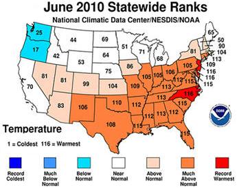
The National Oceanic and Atmospheric Administration (NOAA) State of the Climate report shows the June 2010 average temperature for the United States was 71.4 degrees F, which is 2.2 degrees F above the long-term average (1901-2000).

The average precipitation for June was 3.33 inches, 0.44 inch above the long-term average.

A deep layer of high pressure dominated much of the eastern United States, bringing a southerly influx of warm air, which contributed to record high temperatures.

The Southeast, South and Central regions experienced their second, fifth and seventh warmest June on record, respectively. Only the Northwest averaged a temperature below normal for June.


Record-warm June temperatures occurred in Delaware, New Jersey and North Carolina; each had average temperatures between 5 and 6 degrees F above the long-term mean. Seventeen other states had temperatures that ranked among their 10 warmest for June. Only Oregon and Washington had below normal average temperatures for June.

Halfway through 2010, Maine, New Hampshire, Vermont and Rhode Island have experienced their warmest January-June period on record. Eight other states in the Northeast and Great Lakes areas had a top-10 warm January-June period. In contrast, Florida has observed its seventh-coolest year-to-date on record.

Persistent warmth made the year?s second quarter (April-June) much warmer than normal for 20 states, which had either their warmest, or second-warmest such period on record. This contributed to the warmest April-June on record for both the Northeast and Southeast Climate Regions.

There were significant cool conditions in the West and Northwest. Oregon and Idaho had below normal temperatures for April-June, which led to the Northwest Climate Region?s ninth coolest such period.


The prevailing high pressure that brought warmth to the South and Southeast also blocked many storm systems from entering the region, increasing the threat of drought. However, the active upper level pattern in the northern tier states alleviated drought conditions and produced record flooding in the High Plains.

Michigan had its wettest June on record, followed by: Iowa (2nd wettest), Nebraska and Illinois (3rd), Indiana (4th), Wisconsin (5th), Oregon (6th) and Ohio (10th). Maryland and Virginia experienced below average precipitation for June.

Precipitation during the year?s second quarter (April-June) was more widespread as Iowa and Washington each had its second wettest such period. It was Oregon?s fourth and Nebraska?s ninth wettest while persistent dryness in Maryland, Delaware and New Jersey has resulted in their seventh, ninth and tenth driest such periods, respectively.

Other Highlights

Alex, the first June hurricane in the Atlantic since 1995, made landfall just south of the U.S.-Mexico border on June 30th, affecting portions of South Texas. Alex?s sustained winds of 105 mph made it June?s most intense Atlantic hurricane since Alma in 1966.

NCDC?s Climate Extremes Index for the first half of 2010 was about six percent higher than the historical average. The CEI measures the occurrence of several types of climate extremes, like record or near-record warmth, dry spells, or rainy periods. The elevated 2010 value was driven by large footprints of: extreme wetness (more than three times the average footprint), warm minimum temperatures (?warm overnight lows?), and areas experiencing heavy one-day precipitation events.

NOAA?s Storm Prediction Center tabulated 387 preliminary tornado reports during June. If confirmed, this will be the second most active June on record, behind 1992.

NOAA's Residential Energy Demand Temperature Index indicated June?s temperature-related energy demand for the contiguous U.S. was 11.9 percent above average. The unusual warmth in the highly populated South and Southeast resulted in the second highest June value in 116 years.

Drought coverage decreased slightly in June. The U.S. Drought Monitor reported 8.5 percent of the United States was affected by drought on June 29. Slight improvements were seen in the Northern Rockies and western Great Lakes during June, while conditions deteriorated in Louisiana.

NCDC?s State of the Climate reports are released soon after the end of each month. These analyses are based on preliminary data, which are subject to revision. Additional quality control is applied to the data when late reports are received several weeks after the end of the month and as increased scientific methods improve NCDC?s processing algorithms.

Aircraft Related Performance In Hot Temperatures

For Pilots See Density Altitude
Moisture And Temperature


Other News Stories


Home Aviation News Aviation Stories Of Interest FAA Exam Upcoming Events Links To Other Sites General Aviation Helicopters Medical Factors Facing Pilots
Maintenance and Aircraft Mechanics Hot Air Balloon Aviation Training Handbooks Read Online Aviation History Legal Issues In Aviation Sea Planes Editorials
 
 ?AvStop Online Magazine                                                                 Contact Us                                                  Return To News                                          Bookmark and Share


AvStop Aviation News and Resource Online Magazine

Grab this Headline Animator